Mt. Lemmon is understandably a very popular destination for outdoor recreationists of all stripes. It’s about a one hour drive from the Tucson valley to the little village of Summerhaven near the top of the mountain. Cool, accessible, beautiful!
One of the best payoffs for making the trip up Mount Lemmon is a relatively short and easy hike known as the Aspen Loop. About 4 miles long, the route circles non-descript Marshall Peak, a high point on a forested ridge which separates the Wilderness of Rocks from the headwaters of Sabino Creek. This short hike has plenty to offer: rich conifer forests, aspen groves, fern gardens, a lush and mossy riparian area, and some fine, sweeping views of the Pusch Ridge Wilderness Area.

On the Aspen Loop
The massive 2003 Aspen Fire started in this area, and though the devastation is very evident along many sections of the trail, I can’t help but be impressed and awed by the vigorous signs of rejuvenation obvious everywhere. This remains one of the most delightful hikes in southern Arizona.
For reasons unknown even to myself, I prefer to walk this loop in a clockwise direction, striking first up the Aspen Trail as it leaves the southern end of the parking lot diagonally up a steep hill. A mere quarter of a mile away from the road, one enters a lush stand of trees and ferns, dominated by what seems like hundreds of aspen trees. During most summer months, this area sparkles with green.
The trail soon climbs out of the aspen grove and begins to swing around the southern side of Marshall Peak. At about 1.5 miles from the trailhead, look for a trail spur heading more-or-less west from the main trial. This little spur is about a quarter of mile long and ends at a small rock outcrop known as Lunch Ledge, which sports a grand view of Cathedral Peak in the heart of the Pusch Ridge Wilderness.

Conifer and ferns on the flanks of Marshall Peak
Next, the Aspen Trail continues on to Marshall Saddle where there is a five-way trail intersection. Here, the loop leaves the Aspen Trail and turns east down the Marshall Gulch Trail back towards the parking lot. Marshall Gulch is lovely. The creek bed almost always shows water and the luxuriant green growth is soothing for the heat-weary soul.
Reach the trailhead (32.42782 N, 110.75556 W, WGS84) by following the Catalina Highway from the Tucson to the small settlement of Summerhaven. Drive through Summerhaven and continue about half a mile to trailhead parking at the very end of the road. The Aspen Trail angles up a hillside near the far southern end of the parking area, while the Marshall Gulch Trail heads up the canyon behind a poorly located outhouse on the west side of the parking lot.
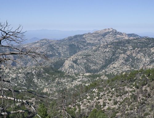
Cathedral Peak seen from Lunch Ledge
Season: Spring, summer and fall. The trailhead is closed to vehicular access for much of the winter, and snow often obscures many sections of the route. This hike can be warm on the exposed ridges during summer months.
Water: As always, bring plenty of your own. Water is usually present in Marshall Gulch, though the flow can slow or cease in the driest months of the year. If you do collect water, purification is recommended before using.
Difficulty: Moderate. The full loop is about 4 miles long with a 720 elevation gain. An even easier and shorter outing is the lovely walk part way up and down Marshall Gulch.
Notes: This is a Forest Service fee area.
Maps: Rainbow Expeditions Santa Catalina Mountains, Green Trails Maps Santa Catalina Mountains, or National Geographic Arizona digital map software.

Click Map for larger image
thanks, i was looking for a good hike for summer… i’ll try this!
Coronado National Forest has a web page about the Aspen Loop here: http://www.fs.fed.us/r3/coronado/forest/recreation/trails/aspen_marshall.shtml
Important access issue! The road to the trail head for this hike will be closed for several months for repairs and "is expected to reopen in spring 2010". Read the Forest Service press release here:
http://www.fs.fed.us/r3/coronado/forest/news/2009/NewsReleaseMarshallGulch100109.pdf
This press release states: "During the closure, access to Marshall Gulch Picnic Area is possible and permissible through use of the hiking trail system. Visitors must access and exit the area via the hiking trails." Some possibilities for such trail access include the Mint Spring Trail which originates in Summerhaven at the end of Carter Canyon Road, or via Sunset Rock Trail which originates in the Soldier Camp area.