Well named, Thimble Peak looks a lot like a giant sewing thimble placed high on the big ridge that separates Sabino and Bear Canyons in the Santa Catalina Mountains north of Tucson. Thimble occupies a prominent position, and once recognized can be seen from most places in Tucson as well as from some sections of the Mt. Lemmon Highway. None the less, Thimble’s summit is not often visited. No trails reach the peak, it is guarded by tall cliffs on many sides, and reaching the true summit requires a few sections of rock climbing.

Thimble Peak from the Bear Canyon Trail take-off
Not obvious from a distance, the peak is cleaved in half. The north summit is the easiest to climb via a 3rd class crack on the north side, but unfortunately is ten or fifteen feet lower in elevation than the south summit. Though not very difficult by rock climbing standards, the south summit presents challenges that must be taken seriously and treated with caution. Climbers should take extreme care as they negotiate a steep rock gulley choked with a few large and loose boulders before reaching the notch between the north and south summits, and a vertical step just below the top. Once in the notch, we roped up and bypassed the vertical step by traversing right (west) past a climbing bolt, into a big crack leading to the summit. But the exposure here is dangerous; so some climbing gear and an experienced party member with rock climbing skills are recommended for the rock climb to the top.
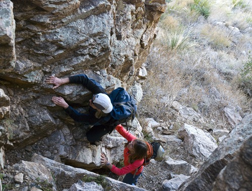
Beginning the summit rock climb
Thimble is often approached from Sabino Canyon using steep bushwhacking routes that take off from the end of the tram road, but here we describe a mellower, though longer route which leaves the Gordan Hirabayashi campground (also known as Prison Camp), just off the Mt. Lemmon Highway.
At milepost 7.3 on the Mt Lemmon Highway, turn west and drive to the trailhead at the west end of the Gordan Hirabayashi campground. This is a fee area. Follow the Sycamore Reservoir Trail west for about 3 miles, past Sycamore Reservoir to the trail junction (32.33618 N, 110.71981 W, WGS84) with the Bear Canyon Trail. This trail junction is marked with several rock cairns. Cross Sycamore Creek and walk southwest on the Bear Canyon Trail for about 0.8 mile to a point (32.34636 N, 110.76287 W, WGS84) where the trial begins its descent to the bottom of Bear Canyon. Leave the trail here and begin the bushwhack towards Thimble Peak. Work west for a ways, and then swing south towards the crest of the high ridge that Thimble rests upon. You are likely to find a few cairns and a faint hiker’s path in this section. Once at the base of Thimble, the climbing route begins on the west side of the peak, at the bottom of a cleft that separates the north and south summits.

Summit view: Sabino Canyon, Blackett’s Ridge and the Tucson valley
Season: Fall, winter and spring.
Water: Seasonal water is sometimes found in Bear and Sycamore Canyons. Purify before drinking. As always, it is best to bring plenty of your own.
Difficulty: The hike to Thimble’s base is moderately difficult, a little over 10 miles round trip with about 2,500 feet of total elevation gain from the trailhead to the peak and back again. A few miles of bushwhacking and the attendant cross country route finding are required. The rock climb to Thimble’s summit should only be attempted by those with appropriate gear and experience. Loose rocks, unstable blocks and the potential for falls are real dangers on this climb.
Maps: Green Trails Santa Catalina Mountains; or National Geographic Arizona digital map software.

Click Map for larger image