Baboquivari Peak is a desert peak about 45 miles southwest of Tucson, Arizona. You can actually see it from many parts of Tucson. If you were to look to the southwest (left of the Tucson Mountains), you will see a low mountain range in the far distance. At the north end (right side of range), you’ll see a flat spot where the top of a mountain should be. That is where the famous Kitt Peak Observatory is located. Following the range to the south (left), you will eventually see what looks like (metaphor alert!) a large incisor tooth jutting up from the gum of the ridge line. That is Baboquivari Peak.

Early morning view of Baboquivari Peak from the east. The South East Arête follows the shadow line from Lion Ledge.
It is a true peak in that gaining access to the summit requires some actual climbing. It is one of the few true peaks in southern Arizona.
The history of climbing on Baboquivari goes back over 100 years to the first recorded ascent in 1898. On July 12 of that year, University of Arizona professor Dr. Forbes and his associate Mr. Montoya made it to the top. They used grappling hooks to aid them in the climbing sections. They had with them enough provisions, including sauerkraut, to camp out on the summit. Legend has it that they built a huge bonfire that night on the summit, and people in villages as far away as Altar, Sonora, Mexico, thought the peak was erupting.
To this day, the Forbes Route remains the route of choice for descent, and is generally considered the easiest way to gain the summit. The only other route that would arguably be easier is the trail from the west side which joins the Forbes Route at the base of the ladder pitch. However, there are two downsides to choosing the route from the West. First, there is no spectacular cliff on the west side visible from the trail; rather, the longer, less steep trail meanders along toward the distant crag until it meets a large rock slab (the Great Ramp) that leads to the bottom of the ladder pitch. Second, to get to the trailhead, one must drive past Robles Junction all the way to the town of Sells on the Tohono O’odham Reservation. At Sells, one must then head south, then turn left (east) and drive a long dirt road along the valley floor to the base of the mountains. At the end of the dirt road is a small park with parking, picnic tables, and the trailhead.

Summit Hut President Dana Davis ascending the Ladder Pitch.
There is an interesting history associated with the west side park and the trail. Back in the 1930s, Congress passed a bill that funded a series of forest fire lookouts to be built on Indian Reservations. Though there were no forests on the then Papago Indian Reservation, Southern Arizona still got its slice of the pork. A forest fire lookout was built on the summit of Baboquivari. What is now a park was originally the base station for the fire lookout. The trail was built by federal government crews, and a wooden ladder was constructed on what is now called the “Ladder Pitch”. You can still see pieces of iron protruding from the rock on the Ladder Pitch, and on the summit, along with a few weathered pieces of lumber from the shack that housed the lookout.
Looking at Baboquivari from the east, one can see a horizontal green line, rising slightly from right to left, near the bottom of the cliff face. This is Lion Ledge. It runs from near the North saddle all the way to the southeast arête – the beginning of the climb by the same name – and beyond. Rated at 5.6, with a five star aesthetic rating, the Southeast Arête is one of the most beloved rock climbs on the mountain. Established in 1957, it was the first route to the summit since Forbes and Montoya achieved the summit in 1898. It was the first real multi-pitch climb, and it was put up by climbers. Names associated with the first ascent are Don Morris, Joanna McComb, Rick Tiorick, Dave Ganci, and Tom Wale.
Babo was then (metaphor alert!) in the embrace of two loving arms, the Forbes Route and the Southeastern Arête, but there remained the alluring blank face of the wall.

A view of the east face from the trail that goes to the north saddle. The line of vegetation at the bottom of the wall is Lion Ledge. The book on the left is Don’s Crack. The faint vertical black stain near the center marks the Spring Route. The actual spring is close to the intersection of Lion Ledge and the stain.
The allure was strong enough to draw some big-name climbers from Colorado. Dave Baker, local climber and founder of the Summit Hut, recalls the events:
Bill Forrest and George Hurley came down from Colorado looking to climb the East face of Babo. Joanna Macomb (now Joanna Coleman) and Dan Jones got wind of their ambitions and tried to beat them to the punch. They ended up making the first ascent of Don’s crack (honoring Don Morris, I believe) – at the time an incredible achievement by Tucson locals.

Dave Baker belaying at the top of the Ladder Pitch.
Baker cautions that his statements are from memory, and that these events happened over 40 years ago, but his statements are consistent with other accounts. He also supplied the author with a copy of an article by Forrest that appeared in the November 1968 issue of Summit magazine. For those who might scoff in my use of the term “alluring” in regards to the east face, consider the first paragraph of Forrest’s article:
In May, 1966, Gary Garber showed me the east face of Baboquivari peak. I was deeply impressed; the wall was massive and overhanging, smooth – imposing. It featured not cracks, ledges, and gullies, but color – black water streaks and yellow – green lichen scattered on vast expanses of tan and golden rhyolite.
It was Forrest who named Lion Ledge, and Cougar Cave – a small grotto just passed the perennial spring located on Lion Ledge near the center of the cliff face. He was also the first to find the best route to the ledge by heading up Thomas Canyon, then contouring up to the right to the north saddle, then straight south to the ledge itself.
Forrest returned a number of times after that initial trip, but it wasn’t until he returned with George Hurley in 1968 that they completed an aide to route up the middle of the face that they named “The Spring Route”. His fascination with Babo, and the dicey route they were following, had not lessened over the years. Here is another excerpt from the Summit magazine article that paints a picture of part of that final, successful attempt:
The morning found us Jumaring up our fixed rope as the desert sun flamed into the sky – breathing life, warmth, and color into the enormous rhyolite wall. The desert, in full bloom, rose in multicolor to meet the bluest of skies as we worked up the overhang. It took us all day Friday to climb at the third and fourth pitches. The nailing was thin – discontinuous and rotten, overhanging and bottoming. George passed blank sections of the third pitch by tying off the tips of angle pitons forced into small, windblown holes.
On their way out, Forrest and Hurley visited Shorty and Irma Riggs at the ranch house at the mouth of Thomas Canyon. The Riggs were very interested in hearing about their successful climb, and presented them with a bouquet of peacock feathers from birds who lived there at the ranch.
Baker provides a little history of the ranch, again from memory:
Shorty and Irma Riggs homesteaded the Riggs Ranch at the bottom of Thomas Canyon. When they left the ranch because of Shorty’s health, their friend Francis Edwards stayed on to watch the place for many years until her death. Not sure I have the name right, but I believe a rancher named Cummings bought the property and built the trail from the ranch house up to the North Saddle. Francis continued to watch the ranch for Mr. Cummings during this time.
Today the ranch is owned by a Tucsonan from whom the nature Conservancy has purchased a usage easement which keeps the property from being further developed. The border of the Tohono O’odham Reservation runs along the ridge of the mountain range and extends to the west. Baboquivari itself is of significant culture importance to the Tohono O’odham people. The east side of the range is Bureau of Land Management (BLM) wilderness, the ranch property, and some State Trust land closer to the main road.
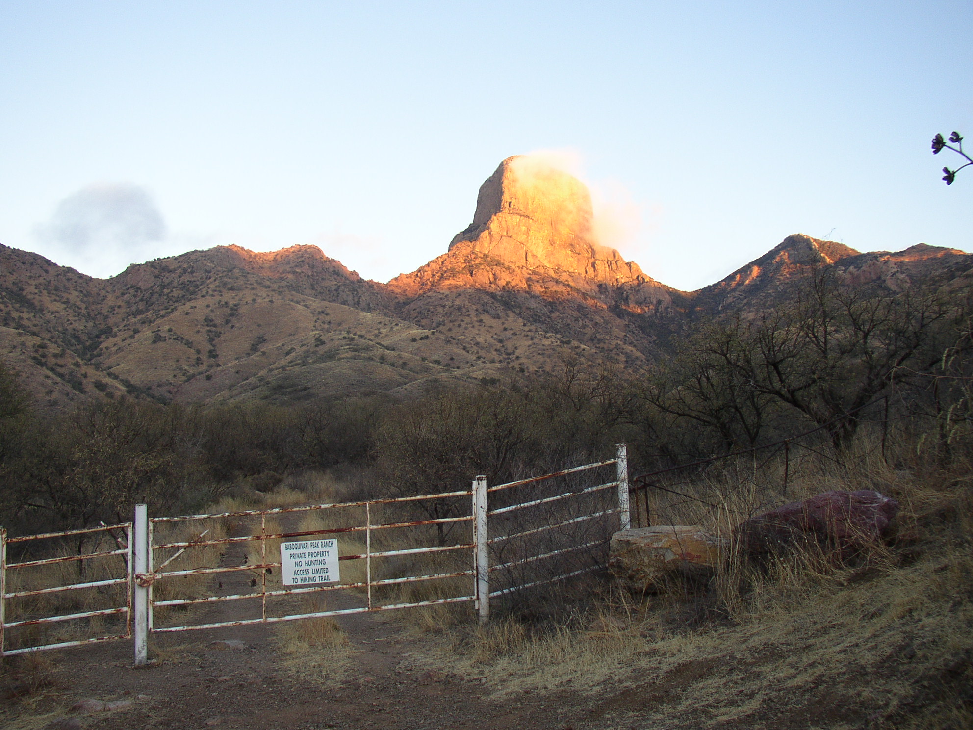 The gate to the ranch with Baboquivari in the distance. The approach starts here.
By the early 1970’s, advances in technology and ethics opened the Golden Age of rock climbing. Nuts and hexes replaced pitons as the tools with which lead climbers were protected. These were quicker and easier to place, and much quicker to clean. They also left no scarring on the rock.
Along with these advancements, a new generation of Tucson locals took to the crags establishing levels of technique and style that rivaled the heroes of the Yosemite Valley. This new generation was composed of high school kids including Mike McEwen, Dave Baker, Mark Axen, Jake Bender, Dennis Coffee, Gary Hervert, Kem Johnson, Scott Williams, and Marti Woerner. They were followed closely by Rich Thompson and Steve Grossman.
Many in this new generation were as deeply affected by Baboquivari as Forrest and Hurley, and like them, befriended the Riggs and returned time and time again to the mountain. They climbed its classics, and attempted a few new routes of their own on the east face. For whatever reason, the west side of Babo was not a big draw for them, and it was not until the 80’s and 90’s that routes went up on the west side.
To many of these locals, the allure of Baboquivari persists. Many will pause and gaze to the southwest when the peak catches the eye. Baker leads a small group of friends on an almost annual pilgrimage up the Forbes Route. Another local had his wedding held in the Signal Hill picnic area of Saguaro National Park West so that Baboquivari would be visible in the background during the ceremony.
Perhaps the grandest expression of love was Fig’s solo ascent of the Spring Route back in the 70’s. He spent three days and nights on the face.
Baboquivari’s superb climbing delights the body, the spectacular scenery inspires the mind, yet there is also an intangible that enters the heart and does not leave. Perhaps it is this feeling, or “presence” as one local described it, that compels Baboquivari climbers to return again and again with able bodies, sharp eyes, and open hearts.
References:
More information regarding Baboquivari can be found in Bob Kerry’s “Backcountry Rockclimbing in Southern Arizona”, posted online here:
http://www.climbaz.com/Backcountry/page_html/page130.html
More general history of early Tucson climbing can be found in John Steiger’s “Climber’s guide to Sabino Canyon and Mount Lemmon Highway” posted online here:
http://www.climbaz.com/sabino_canyon/page_html/page032.html
An interesting interview with Steve Grossman which provides a first person account of the golden years is posted here:
http://climbaz.com/interviews/sg_part1.html
