When it’s time to cool off, the Wilderness of Rocks is a popular destination for Tucson area hikers. At an elevation of over 7,000 feet, the Wilderness of Rocks stretches across a broad, rocky bench perched beneath the high summit ridge of Mt. Lemmon. The headwaters of Lemmon Creek gather here, and the small stream almost always shows water. Shaded in most places by trees and cliffs, this riparian zone can be a delightful reprieve from the hot deserts far below.
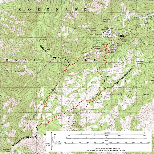
The loop hike described here begins almost from the very top of Mt. Lemmon. Heading west from the trailhead, the route works down Mt Lemmon’s broad summit ridge, and then turns south onto a prominent spur ridge which shows great views of Oro Valley, the headwaters of Romero Canyon, and the high peaks scattered along Pusch Ridge.

Weathered formations in the Wilderness of Rocks
Once in the Wilderness of Rocks, hikers wander among stately stands of Ponderosa pines, fern gardens and untold numbers of gleaming white rock formations and gargoyles. It’s great hanging out beneath the tall pines that line Lemmon Creek’s shallow pools.

Lemmon Creek
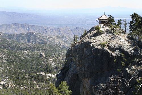
Finish the loop by hiking up the Lemmon Rock Lookout Trail. This steep section climbs 1,800 feet in under 2.5 miles, a tough climb! Watch for rock climbers on the long 400 foot south ridge of Rappel Rock, easily seen from several sections of the trail. No surprise, the Lemmon Rock Lookout Trail ends near Lemmon Rock Lookout, a small building listed in the US National Register of Historic Places and which is still staffed from May through September. The short side trip to the lookout with its fantastic views of the Catalina Mountains and much of southern Arizona is very worthwhile.

Lemmon Rock Lookout
Reach the trailhead (32.44036 N, 110.7858 W, WGS84) by following the Catalina Highway from the Tucson valley towards the small settlement of Summerhaven. Just short of Summerhaven, turn right (west) onto “Ski Run Rd”. Continue on Ski Run Road past the ski facility through a gate (often closed during winter months), and on up the narrow winding road to the trailhead parking lot near the top of Mt Lemmon.
The Mt. Lemmon Trail #5 leaves the west side of the parking lot right next to a fenced electrical facility, crosses a dirt road and then joins an old jeep trail heading west along the broad summit ridge. A few tenths of a mile later, the junction with the Lemmon Rock Lookout Trail is reached, which marks the beginning and end of the loop route. Clockwise or counter-clockwise? The route is described in a counter-clockwise direction above, but take your pick.
Season: Spring, summer and fall. The trailhead is closed to vehicular access for much of the winter, and snow often obscures many sections of the route. This hike can be quite warm on the exposed ridges during summer months.
Water: Water is usually present in Lemmon Creek, though the flow can slow or cease in the driest months of the summer. If you do collect water, purification is recommended before using. Make sure you have plenty of water for the more exposed hiking getting into and out of the Wilderness of Rocks.
Difficulty: Somewhat difficult. About 8.5 miles long with a 2,000 elevation drop and then gain. Some sections of trail can be hard to follow, so map and compass/GPS are recommended.
Notes: The trailhead is in a Forest Service fee area. The area was impacted by the 2003 Aspen Fire.
Maps: Rainbow Expeditions Santa Catalina Mountains, Green Trails Maps Santa Catalina Mountains, or National Geographic Arizona digital map software.
Click Map for larger image

I did this hike two days ago with my dog. All was going well until I realized I need to invest in a water purification device. I had plenty of drinking water in my hydration pack, but it was REALLY hot in the Wilderness of Rocks and could have used more later. Gave my boy most of my water. On the way out (we looped from Mt Lemmon trail #5 and up Lemmon LO trail)we had two black bears saunter in about 15 yards from us on a rest. Whistles, wild waving of bandanas and dog growls got us out from a potentially bad situation. We hauled ass up the last 2.5 miles at bear dinner time and made it up safe and secure…up the switchbacks. We are still so sore but can’t wait to try it again. Beautiful scenery from the summit ferns to the rock sculptures to the pine groves to rappel rock. Wish I had been able to enjoy the climb up a bit more…and been able to purify some water.