Last month I reviewed the SPOT Satellite Messenger in a blog entry titled “See SPOT”. In the review I reported that while using SPOT on the Arizona Trail, I experienced an 80% transmission success rate, speculating that the failed transmissions were due to hillsides or foliage blocking SPOT’s view of the sky.
Last week I attended the major trade show of the outdoor industry, the Outdoor Retailer Winter Market, in Salt Lake City. I stopped by the SPOT booth and talked to Donnie Hatch of Spot, Inc. about the transmission success rate I had experienced using SPOT.
Donnie was instantly interested, and asked “How did you orient your SPOT during transmissions?” I told him that I typically propped my SPOT up in an upright position, assuming that the antenna was located at the top of the device.
Donnie then told me that SPOT’s antenna was located under the face of the device, below the SPOT logo. He went on to say that for best transmission results it is very important to set SPOT on its back, with the face of SPOT oriented skywards. Though this information is not currently available in the materials that are packaged with SPOT, a tech article about this topic is available online here.
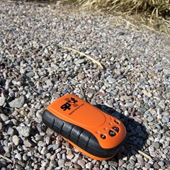
Right (above); wrong (below)

I used the spot on a 5 day backpack and also missed some "spots". I did lay the spot flat while its was transmitting. I did not however, watch closely for the five second flash indicating a send. Also I was not careful to make sure that there was no brush or tree cover to interfere with the transmission. Another thing that is bugging me is the lack of info in the website on how to place multiple spots on a Google map. I need to check with you Dave on how you did it. Keep on Spotin’!
Hi Dave
A Tucson friend tipped me off to your blog. Nice start! As frequent hikers, travelers, and new Tucsonians I’m glad to see you talking about interesting hikes and gear. Keep up the good work.
– RL
@Craig
When we put together a Google Map showing multiple transmission locations along the Arizona Trail, we did not rely upon any feature that SPOT, Inc offers. Instead we used a feature called My Maps from Google. You’ll find more information at this address — http://maps.google.com/support/bin/topic.py?topic=11305