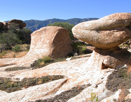
The Little Rincon Mountains lay just east the Rincon Mountains, separated from their much larger sibling by Ash Creek and Happy Valley. These “little” mountains offer a wonderfully scenic hike up a rugged, unnamed canyon, through a maze of spectacular granite rock formations, to a perched valley called Hidden Pasture. Hidden Pasture is tucked between North Star Peak and the range’s high point, Forest Hill.
This hike is considerably more challenging than the vital statistics would suggest, with a one way distance of about 3.5 miles and an elevation gain of 900 feet to Hidden Pasture. Though a trail has been constructed to Hidden Pasture, it has been a very, very long time since it has been regularly maintained, and it has fallen into a state of disrepair. For the first mile or so, the trial is relatively easy to follow, but higher up it is quite challenging to stay the course in the many sections where it has become obscured by washouts and brush.
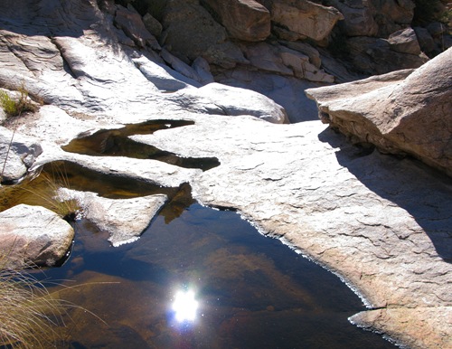
Challenging as it is, the old trail offers a better route to Hidden Pasture than one finds bushwhacking through several sections of the canyon, which present a series of obstacles including waterfalls, pour-offs, huge boulders, cliff barriers, brush, cat-claw and the like.
This cannot be considered a trail hike. It is definitely a wilderness route and as such requires cross-country navigation skills and good judgment. Take care!
The wild granite canyon is quite beautiful, and the oak studded, grassy bottom of Hidden Pasture is a contrast to the rocky terrain leading up to it. Once at Hidden Pasture, you might decide to bushwhack the additional mile to the top of Forest Hill adding another 1,200 feet of elevation gain. Nice views of Rincon Peak, the San Pedro River valley, the Dragoons, and Paige Canyon are ample rewards for this effort.

Hidden Pasture and North Star Peak
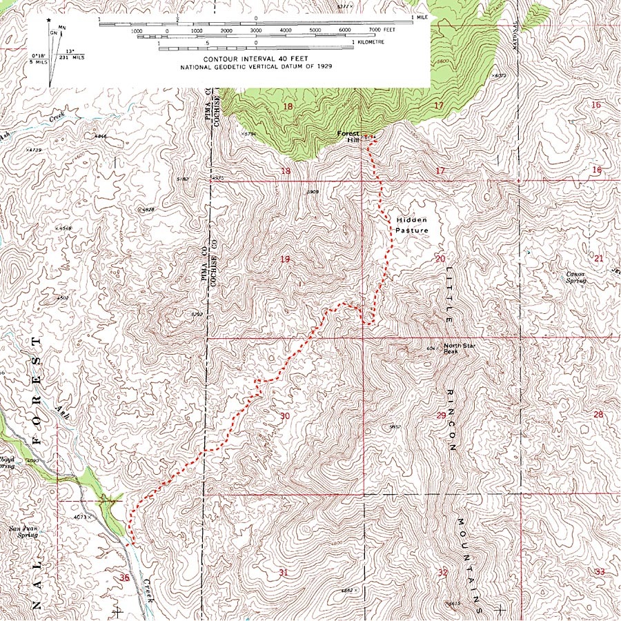
Park your car in a small circular pullout on the east side of Mescal Road (32.08924 N, 110.45779 W, WGS84), about 10 miles north of Exit 297 on I-10. Pick up the trail due east of the parking circle, about 20 or 30 yards uphill from the bottom of Ash Creek. Turn north on the trail, which soon swings to the northeast above a canyon heading towards Hidden Pasture. Early on, the trail passes through a gate (32.09125 N, 110.45779 W, WGS84), giving confirmation that you are on the route. At about 2.5 miles, the trail climbs high above the canyon on the right (southeast) side to avoid a few waterfalls and huge jumbled boulders in the canyon bottom. The trail passes through another gate near the beginning of this climb (32.11126 N, 110.43573 W, WGS84). After climbing steeply for a while above the gate, the trail turns and wends its way to Hidden Pasture past several large weathered rock formations.
Season: Fall, winter and spring. This hike can be hot, especially in the summer.
Water: Seasonal and intermittent. Bring plenty of your own
Difficulty: Advanced. 3.5 miles one way with 900 feet of elevation gain to Hidden Pasture; 4.5 miles one way with 2,100 foot elevation gain to Forest Hill. Moderately strenuous. Route finding is challenging; map, compass and/or GPS are very useful. Brushy, so long pants are recommended. The trail described here is faint and difficult to follow in many places, so consider this a wilderness route rather than a trail walk. Negotiating boulder piles, cliffs and waterfalls along the route demands care and good judgment.
Maps: USGS Galleta Flats West, AZ (Route to Hidden Pasture) and USGS Happy Valley, AZ (Forest Hill); Green Trails Recreation Map – Saguaro National Park; or National Geographic Arizona digital map software.
Click map for larger image
Looks like a nice secluded hike Dave. I’d be intereseted in hearing your views on the Rincon Creek trail, either as an ascent (for those who have X9 access) or as a descent from Miller Saddle. How would it compare with the trail from Madrona RS to Mica.
It has been years (maybe decades) since the trail from Madrona Ranger Station to Happy Valley Saddle has received regular maintenance, especially the section climbing east from the mouth of Rincon Creek towards Happy Valley Saddle. It is pretty easy to wander off the old trail bed because of overgrowth and washouts, and there are several spots where the hiker must wade through clumps of catclaw now living on the trail. This is in sharp contrast to the trails from Madrona to Manning Camp, which have been well maintained and are in pretty good shape.
However, for hikers willing and able to deal with these difficulties, the old trail does serve up a rewarding and scenic hike in a primitive setting.
What always concerns me about hiking down there in the fall and winter are hunters flinging bullets over my head. Did you experience any of that at hidden pasture?
Jay P.
My last trip to Hidden Pasture was on the first Saturday of December, 2008. It was quiet all day and I saw and heard no one at all during the hike. Only a few of the car camp sites along Ash Creek were occupied. I must confess that I do not keep careful track of the various hunting seasons, but I would guess that nothing was in season at the time.