What’s not to like about the Finger Rock trailhead at the end of Alvernon Way? Quite literally at Tucson’s backdoor, this trailhead offers convenient access to one of the more spectacular portions of the “Front Range” of the Santa Catalina Mountains.

Pontatoc Canyon left, Pontatoc Ridge right
In addition to the popular Finger Rock Trail, two other trails originate here: the Pontatoc Trail and the Pontatoc Ridge Trail. These two trails are not nearly as strenuous as the Finger Rock Trail, but both offer great hiking. Pontatoc Canyon and Pontatoc Ridge are named for the nearby Pontatoc Mine, which was first worked way back in 1907.
The Pontatoc Ridge Trail is appealing for its sweeping views of nearly the entire Tucson valley. It ascends a prominent rocky ridge, abruptly ending just below some abandoned mine shafts bored into a huge rock cliff. Take care up here; the area where the trail ends is ringed with big cliffs, and the scramble to the mine shafts above is steep and loose. The Ridge Trail does gain some altitude, but on my last trip here we barely noticed the steeper sections of the trail, there was so much to look at and enjoy.

Peering into Pontatoc Canyon from the Ridge Trail
The Pontatoc Trail has a distinctly different character, as it tends to remain within the confines of Pontatoc Canyon. Though this trail sometimes snakes along the canyon bottom, it spends much more time traversing hillsides above the canyon in order to avoid a rocky gorge below. It is more than a mile longer than the Ridge Trail, and the steep sections are distinctly more demanding. I really enjoy the terrain and scenery in the upper reaches; in spite of the relatively short distance from the road, this area feels pleasantly wild and remote.
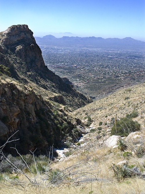
High up in Pontatoc Canyon
Alternatively, you may prefer an easy, yet scenic outing; the first 0.8 miles of the trail has little altitude gain, but you’l enjoy spectacular views of craggy ridgelines high above as you wander through a lush Sonoran environment.
To reach the trailhead, drive to the very northern end of Alvernon Way. You can’t follow Alvernon all the way from Tucson as there is a big gap north of River Road. Pick up the final northern spur of Alvernon Way by turning north off Skyline Drive; the trailhead parking lot at the end of Alvernon is obvious and well marked.
The two Pontatoc Trails and the Finger Rock Trail all share the same trail head; the Pontatoc Trails split off right just a few hundred feet from the trail head. After about 0.8 miles you will reach another trail junction; the Pontatoc Trail stays left, while the Pontatoc Ridge Trail swings right and begins its climb to the spine of the big ridge above.
Season: Fall, winter and spring. This hike can be very hot, especially in the summer.
Water: Seasonal pools appear in Pontatoc Canyon; bring plenty of your own.
Note: Dogs are not permitted on these trails.
Difficulty: Moderately strenuous, though walking just the first mile makes for a much easier hike. The Pontatoc Canyon Trail is about 3.5 miles one way, with a 2,200 foot elevation gain. The Pontatoc Ridge Trail is easier; about 2.4 miles one way, with a 1,850 foot elevation gain. Walking just the first 0.8 miles of trail yields a pleasant and scenic outing, with only a 300 foot elevation gain.
Maps: Rainbow Expeditions Santa Catalina Mountains, Green Trails Maps Santa Catalina Mountains, or National Geographic Arizona digital map software.

Click map for larger image
Hi Dave, just thought I’d pass on this link in which you are mentioned!
http://www.trailjournals.com/entry.cfm?id=264358
Thank you for the link! It was fun running into yappy and Da on the way to work that morning and I enjoyed reading yappy’s account of the chance encounter.